jasaukurtanah.com – Salah satu alternatif metode pemetaan secara fotogrametri adalah pemotretan udara menggunakan wahana UAV (unmanned aerial vehicle). Dengan memanfaatkan wahana UAV tempat take off dan landing wahana dapat lebih fleksibel pada area terbuka di sekitar area pemotretan, waktu pemotretan dapat dilakukan kapanpun pada cuaca cerah, serta berbiaya rendah. Pada lokasi pegunungan atau lokasi beresiko tinggi karena adanya turbelensi, wahana tanpa awak meminimalkan resiko karena tidak adanya orang yang ikut serta dalam penerbangan. Wahana UAV juga efektif dalam pengambilan foto udara pada spot kecil lokasi pemetaan. Penggunaan wahana UAV dalam pemotretan udara telah menggunakan sistem robotik sehingga meminimalkan kesalahan operator dalam pengendalihan wahana karena terbang wahana dilakukan secara full autopilot sistem hingga parameter yang dipelukan sesuai kaidah fotogrametri tetap terjaga.

Gambar 01. Para Peserta dan Trainer Pelatihan UAV WGS-engineering
Pelatihan Unmanned Aerial Vehicle atau disingkat UAV bertujuan untuk memberikan edukasi kepada para peserta pelatihan terkait salah satu variasi metode akuisisi data dalam survei dan pemetaan. Pemetaan menggunakan UAV tergolong sebagai pengukuran secara fotogrametris dimana memanfaatkan foto udara untuk pengambilan datanya.
Pada tanggal 17 – 19 Maret 2017, WGS-engineering kedatangan tamu dari Kalimantan Selatan. Tepatnya, dari Dinas Ketahanan Pangan dan Hortikultura Kabupaten Kotabaru, Provinsi Kalimantan Selatan. Pelatihan ini diselenggarakan dalam bentuk Private Class yang berarti tanggal dan tempat menyesuaikan dari permintaan client, dalam hal ini Dinas Ketahanan Pangan dan Hortikultura Kabupaten Kotabaru. Masalah yang dihadapi oleh instansi tersebut adalah selama ini data penunjang untuk kegiatan mereka adalah memanfaatkan data citra Landsat untuk menentukan klasifikasi lahan termasuk sampai menentukan luas lahan pada area tertentu. Yang jadi masalah disini adalah resolusi spasial yang dimiliki citra Landsat tersebut kurang mumpuni untuk menangani pekerjaan mereka dan dari hal tersebut sering dijumpai masalah di lapangan dimana ketika dicek kondisi aktualnya terkadang terdapat kekeliruan yang cukup fatal. Semisal ambil contoh, hasil klasifikasi menunjukkan bahwa pada area tertentu merupakan golongan sawah siap panen, akan tetapi ketika cross check di lapangan ternyata menunjukan hasil yang berbeda. Begitu pula dengan estimasi luasan lahannya, terdapat beberapa perbedaan yang cukup mencolok ketika dilakukan uji lapangan. Berangkat dari hal tersebut pula diputuskan untuk mengikuti pelatihan pemanfaatan aplikasi UAV ini. Pelatihan UAV foto udara ini berlangsung selama 3 hari. Untuk kelas teori dan processing data dilaksanakan di Wisma Keluarga Alumni Gadjah Mada (KAGAMA) dan untuk kelas praktik akusisi foto udara dilaksanakan di luar ruangan, termasuk untuk praktik dalam studi kasus tertentu.

Gambar 02. Pengarahan Peserta Pelatihan
Pada hari pertama pelatihan UAV, peserta pada mulanya diberikan materi serta konsep dasar dari Survei Pemetaan baik secara umum maupun secara spesifik fotogrametris. Mulai dari penjelasan konsep dasar keilmuan geodesi sampai pada penjelasan terkait resolusi spasial dan strategi akuisisi data di lapangan. Untuk praktik lapangan di hari pertama, peserta pelatihan UAV dikenalkan terlebih dahulu terhadap perangkat yang sering digunakan dalam pemetaan menggunakan wahana UAV seperti Multirotor Quadcopter dan Fix Wing. Peserta juga diberikan kesempatan untuk mencoba wahana tersebut dan mulai belajar menerbangkan drone. Cukup sulit memang, karena sebelumnya para peserta belum pernah menerbangkan drone secara langsung, akan tetapi dalam waktu singkat para peserta pelatihan UAV sudah cukup terbiasa untuk take off dan landing menggunakan drone. Praktik sendiri dilakukan di komplek boulevard Grha Sabha Pramana Universitas Gadjah Mada (UGM). Pada praktek hari pertama ini juga dipraktikkan pengambilan foto udara secara sederhana dan pengolahan datanya.
Pelatihan pada hari kedua mulai dilakukan pemotretan foto udara baik secara manual maupun secara auto pilot. Para peserta juga diajarkan bagaimana caranya menentukan jalur terbang sendiri sampai strategi akusisi data di lapangan. Pelatihan UAV pada hari kedua ini lebih banyak memakan waktu di lapangan, hal ini ditujukan agar para peserta pelatihan terbiasa menggunakan drone baik secara manual maupun secara auto pilot. Praktik pelatihan uav ini dilakukan di area persawahan di daerah Ngaglik, Sleman. Hal ini dilakukan karena pada kasus kasus tertentu para peserta sering mendapatkan permasalahan ketika melakukan identifikasi lahan terutama pada area persawahan. Setelah dirasa terbiasa dengan penerbangan secara manual dan auto pilot serta akuisisi data foto udara , para peserta kembali ke ruangan dan mulai untuk dilakukan pemrosesan data, mulai dari download data sampai pada pembuatan mozaik foto.

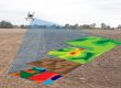
Gambar 03. Akuisisi data lapangan oleh peserta secara langsung
Pada hari ketiga pelatihan UAV, para peserta diarahkan untuk mematangkan konsep penerbangan dan pemrosesan data. Untuk praktik sendiri kali ini dilakukan sama lokasinya dengan pelatihan UAV hari pertama yakni di sekitaran komplek boulevard Grha Sabha Pramana Universitas Gadjah Mada. Terlihat pada hari ketiga ini para peserta sudah mulai terbiasa dengan menggunakan wahana UAV tersebut. Pun demikian untuk pengolahan datanya.
Baca Juga :
- Pelatihan GNSS/GPS Geodetic
- Jadwal Pelatihan Survei dan Pemetaan
- Mengenal Fotogrametri, Salah Satu Cabang Keilmuan di bidang Geodesi

Gambar 04. Para Peserta Diajarkan Processing Data
Adapun secara umum pelatihan pemanfaatan aplikasi UAV ini bertujuan untuk memberikan edukasi kepada para peserta bagaimana caranya untuk akusisi data di lapangan secara baik dan benar. Juga demikian dalam hal pemrosesan data, para peserta diajarkan benar benar dari nol mulai dari tahap instalasi awal sampai pada finishing report nya. Wahana yang digunakan dalam pelatihan ini ada 3 unit yaitu Multirotor Dji Phantom 3 Professional dan Dji Phantom 4 Professional dan satu unit Fix Wing tipe Skywalker 2014.
Demikian field repot dari pelatihan pemanfaatan aplikasi UAV untuk survei dan pemetaan ini. Jika dari para pembaca sekalian ada yang membutuhkan pelatihan serupa bisa menghubungi kami melalui portal email berikut ini (click disini).